National Register of Historic Places listings in Seminole County, Florida

This is a list of the National Register of Historic Places listings in Seminole County, Florida.
This is intended to be a complete list of the properties and districts on the National Register of Historic Places in Seminole County, Florida, United States. The locations of National Register properties and districts for which the latitude and longitude coordinates are included below, may be seen in a map.[1]
There are 18 properties and districts listed on the National Register in the county.
This National Park Service list is complete through NPS recent listings posted April 26, 2024.[2]
Map all coordinates using OpenStreetMap
Download coordinates as:
- KML
- GPX (all coordinates)
- GPX (primary coordinates)
- GPX (secondary coordinates)
| Alachua - Baker - Bay - Bradford - Brevard - Broward - Calhoun - Charlotte - Citrus - Clay - Collier - Columbia - DeSoto - Dixie - Duval - Escambia - Flagler - Franklin - Gadsden - Gilchrist - Glades - Gulf - Hamilton - Hardee - Hendry - Hernando - Highlands - Hillsborough (Tampa) - Holmes - Indian River - Jackson - Jefferson - Lafayette - Lake - Lee - Leon - Levy - Liberty - Madison - Manatee - Marion - Martin - Miami-Dade (Miami) - Monroe - Nassau - Okaloosa - Okeechobee - Orange - Osceola - Palm Beach - Pasco - Pinellas - Polk - Putnam - St. Johns - St. Lucie - Santa Rosa - Sarasota - Seminole - Sumter - Suwannee - Taylor - Union - Volusia - Wakulla - Walton - Washington |
Current listings
| [3] | Name on the Register[4] | Image | Date listed[5] | Location | City or town | Description |
|---|---|---|---|---|---|---|
| 1 | Bradlee-McIntyre House | 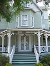 | March 28, 1991 (#72000352) | 130 West Warren Avenue 28°39′50″N 81°22′04″W / 28.6639°N 81.3678°W / 28.6639; -81.3678 (Bradlee-McIntyre House) | Longwood | |
| 2 | Browne-King House | 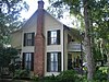 | September 20, 2001 (#01001023) | 322 King Street 28°40′18″N 81°12′50″W / 28.6717°N 81.2139°W / 28.6717; -81.2139 (Browne-King House) | Oviedo | |
| 3 | R. W. Estes Celery Company Precooler Historic District | 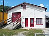 | September 20, 2001 (#01001022) | 159 North Central Avenue 28°40′18″N 81°12′33″W / 28.6717°N 81.2092°W / 28.6717; -81.2092 (R. W. Estes Celery Company Precooler Historic District) | Oviedo | |
| 4 | First Methodist Church of Oviedo | 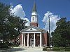 | July 18, 2007 (#07000743) | 263 King Street 28°40′20″N 81°12′48″W / 28.6722°N 81.2133°W / 28.6722; -81.2133 (First Methodist Church of Oviedo) | Oviedo | |
| 5 | Georgetown Historic District |  | October 8, 2020 (#100005670) | East 2nd St., Mellonville, Celery, and Sanford Aves. 28°48′17″N 81°15′39″W / 28.8046°N 81.2608°W / 28.8046; -81.2608 (Georgetown Historic District) | Sanford | |
| 6 | Hopper Academy | 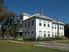 | May 6, 2015 (#15000209) | 1101 Pine Ave. 28°48′09″N 81°15′45″W / 28.8024°N 81.2624°W / 28.8024; -81.2624 (Hopper Academy) | Sanford | |
| 7 | Lake Mary Chamber of Commerce Building | 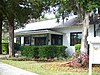 | February 11, 2004 (#04000022) | 158 North Country Club Road 28°45′29″N 81°19′21″W / 28.7581°N 81.3225°W / 28.7581; -81.3225 (Lake Mary Chamber of Commerce Building) | Lake Mary | |
| 8 | Longwood Historic District | 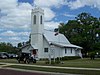 | October 5, 1990 (#90001480) | Roughly bounded by West Pine Avenue, South Milwee Street, Palmetto Avenue and County Road 427 28°41′57″N 81°20′54″W / 28.6992°N 81.3483°W / 28.6992; -81.3483 (Longwood Historic District) | Longwood | |
| 9 | Longwood Hotel | 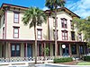 | May 10, 1984 (#84000963) | Old Dixie Highway 28°42′01″N 81°20′52″W / 28.7003°N 81.3478°W / 28.7003; -81.3478 (Longwood Hotel) | Longwood | |
| 10 | Nelson and Company Historic District | 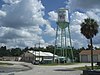 | September 20, 2001 (#01001010) | 110-166 East Broadway Street and 30-110 Station Street 28°40′05″N 81°32′53″W / 28.6681°N 81.5481°W / 28.6681; -81.5481 (Nelson and Company Historic District) | Oviedo | |
| 11 | Old Fernald-Laughton Memorial Hospital | 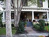 | May 21, 1987 (#87000805) | 500 South Oak Avenue 28°48′27″N 81°16′10″W / 28.8075°N 81.2694°W / 28.8075; -81.2694 (Old Fernald-Laughton Memorial Hospital) | Sanford | |
| 12 | Ritz Theater | 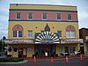 | January 29, 2001 (#00001130) | 201 South Magnolia Avenue 28°48′37″N 81°16′01″W / 28.8103°N 81.2669°W / 28.8103; -81.2669 (Ritz Theater) | Sanford | |
| 13 | St. James A. M. E. Church | 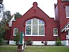 | April 24, 1992 (#92000352) | 819 Cypress Avenue 28°48′16″N 81°15′50″W / 28.8044°N 81.2639°W / 28.8044; -81.2639 (St. James A. M. E. Church) | Sanford | |
| 14 | Sanford Commercial District | 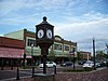 | June 15, 1976 (#76000606) | Parts of 1st, 2nd, and Commercial Streets, between Palmetto and Oak Streets 28°48′42″N 81°16′03″W / 28.8117°N 81.2675°W / 28.8117; -81.2675 (Sanford Commercial District) | Sanford | |
| 15 | Sanford Grammar School |  | November 23, 1984 (#84000253) | 7th and Myrtle Streets 28°48′20″N 81°16′15″W / 28.8056°N 81.2708°W / 28.8056; -81.2708 (Sanford Grammar School) | Sanford | |
| 16 | Sanford Residential Historic District |  | December 15, 1989 (#89002119) | Roughly bounded by Sanford Avenue, 14th Street, Elm Avenue, and 3rd Street 28°48′17″N 81°16′09″W / 28.8047°N 81.2692°W / 28.8047; -81.2692 (Sanford Residential Historic District) | Sanford | |
| 17 | Seminole County Home |  | June 10, 1999 (#99000696) | 300 Eslinger Way[6] 28°44′35″N 81°17′58″W / 28.7431°N 81.2994°W / 28.7431; -81.2994 (Seminole County Home) | Sanford | |
| 18 | Wheeler-Evans House | 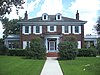 | September 20, 2001 (#01001024) | 340 South Lake Jesup Avenue 28°39′57″N 81°12′45″W / 28.6658°N 81.2125°W / 28.6658; -81.2125 (Wheeler-Evans House) | Oviedo |
See also
Wikimedia Commons has media related to National Register of Historic Places in Seminole County, Florida.
- List of National Historic Landmarks in Florida
- National Register of Historic Places listings in Florida
References
- ^ The latitude and longitude information provided in this table was derived originally from the National Register Information System, which has been found to be fairly accurate for about 99% of listings. Some locations in this table may have been corrected to current GPS standards.
- ^ National Park Service, United States Department of the Interior, "National Register of Historic Places: Weekly List Actions", retrieved April 26, 2024.
- ^ Numbers represent an alphabetical ordering by significant words. Various colorings, defined here, differentiate National Historic Landmarks and historic districts from other NRHP buildings, structures, sites or objects.
- ^ "National Register Information System". National Register of Historic Places. National Park Service. March 13, 2009.
- ^ The eight-digit number below each date is the number assigned to each location in the National Register Information System database, which can be viewed by clicking the number.
- ^ "Seminole renames road to honor retiring Sheriff". 11 October 2016.
- v
- t
- e
by county
- Alachua
- Baker
- Bay
- Bradford
- Brevard
- Broward
- Calhoun
- Charlotte
- Citrus
- Clay
- Collier
- Columbia
- DeSoto
- Dixie
- Duval
- Escambia
- Flagler
- Franklin
- Gadsden
- Gilchrist
- Glades
- Gulf
- Hamilton
- Hardee
- Hendry
- Hernando
- Highlands
- Hillsborough
- Holmes
- Indian River
- Jackson
- Jefferson
- Lake
- Lee
- Leon
- Levy
- Liberty
- Madison
- Manatee
- Marion
- Martin
- Miami-Dade
- Monroe
- Nassau
- Okaloosa
- Okeechobee
- Orange
- Osceola
- Palm Beach
- Pasco
- Pinellas
- Polk
- Putnam
- Santa Rosa
- Sarasota
- Seminole
- St. Johns
- St. Lucie
- Sumter
- Suwannee
- Taylor
- Union
- Volusia
- Wakulla
- Walton
- Washington


