National Register of Historic Places listings in Flagler County, Florida
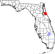
This is a list of the National Register of Historic Places listings in Flagler County, Florida.
This is intended to be a complete list of the properties and districts on the National Register of Historic Places in Flagler County, Florida, United States. The locations of National Register properties and districts for which the latitude and longitude coordinates are included below, may be seen in a map.[1]
There are 13 properties and districts listed on the National Register in the county.
This National Park Service list is complete through NPS recent listings posted April 26, 2024.[2]
Map all coordinates using OpenStreetMap
Download coordinates as:
- KML
- GPX (all coordinates)
- GPX (primary coordinates)
- GPX (secondary coordinates)
| Alachua - Baker - Bay - Bradford - Brevard - Broward - Calhoun - Charlotte - Citrus - Clay - Collier - Columbia - DeSoto - Dixie - Duval - Escambia - Flagler - Franklin - Gadsden - Gilchrist - Glades - Gulf - Hamilton - Hardee - Hendry - Hernando - Highlands - Hillsborough (Tampa) - Holmes - Indian River - Jackson - Jefferson - Lafayette - Lake - Lee - Leon - Levy - Liberty - Madison - Manatee - Marion - Martin - Miami-Dade (Miami) - Monroe - Nassau - Okaloosa - Okeechobee - Orange - Osceola - Palm Beach - Pasco - Pinellas - Polk - Putnam - St. Johns - St. Lucie - Santa Rosa - Sarasota - Seminole - Sumter - Suwannee - Taylor - Union - Volusia - Wakulla - Walton - Washington |
Current listings
| [3] | Name on the Register[4] | Image | Date listed[5] | Location | City or town | Description |
|---|---|---|---|---|---|---|
| 1 | Bulow Plantation Ruins |  | September 29, 1970 (#70000185) | 3501 Old Kings Road 29°26′10″N 81°08′28″W / 29.436111°N 81.141111°W / 29.436111; -81.141111 (Bulow Plantation Ruins) | Flagler Beach | Bulow Plantation Ruins Historic State Park |
| 2 | Bunnell City Hall | 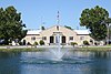 | February 4, 2019 (#100003406) | 200 South Church Street 29°27′57″N 81°15′22″W / 29.465739°N 81.255973°W / 29.465739; -81.255973 (Bunnell City Hall) | Bunnell | Part of the Florida's New Deal Resources MPS - Bunnell Coquina City Hall |
| 3 | Bunnell Water Tower |  | February 4, 2019 (#100003407) | 100 Utility Street 29°28′03″N 81°15′37″W / 29.467580°N 81.260250°W / 29.467580; -81.260250 (Bunnell Water Tower) | Bunnell | Bunnell Water Tower |
| 4 | Cherokee Grove |  | May 2, 1997 (#97000379) | West of State Road A1A and east of Interstate 95, on Pellicer Creek, approximately ¼ mile south of the St. Johns-Flagler county line 29°39′30″N 81°14′15″W / 29.658333°N 81.2375°W / 29.658333; -81.2375 (Cherokee Grove) | Palm Coast | Princess Place Preserve |
| 5 | Dixie Highway-Hastings, Espanola and Bunnell Road |  | April 20, 2005 (#05000311) | Roughly Espanola in Flagler County to County Route 204 in St. Johns County 29°34′49″N 81°20′35″W / 29.580278°N 81.343056°W / 29.580278; -81.343056 (Dixie Highway-Hastings, Espanola and Bunnell Road) | Espanola | Extends into St. Johns County |
| 6 | Espanola Schoolhouse |  | July 22, 2020 (#100005382) | 298 Knox Jones Avenue 29°30′23″N 81°18′33″W / 29.506439°N 81.309133°W / 29.506439; -81.309133 (Espanola Schoolhouse) | Bunnell | Espanola Schoolhouse (Florida's Historic Black Public Schools MPS) |
| 7 | Holden House | 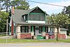 | October 16, 2018 (#SG100003020) | 204 E. Moody Blvd. 29°28′00″N 81°15′25″W / 29.466770°N 81.257060°W / 29.466770; -81.257060 (Holden House) | Bunnell | Holden House Museum and home of the Flagler County Historical Society |
| 8 | Mala Compra Plantation Archeological Site | 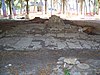 | March 5, 2004 (#04000142) | Approximately 1000 feet west of the intersection of North Oceanshore Boulevard and Mala Compra Drive 29°36′54″N 81°12′14″W / 29.615°N 81.203889°W / 29.615; -81.203889 (Mala Compra Plantation Archeological Site) | Palm Coast | Mala Compra Plantation Archeological Site |
| 9 | Marine Studios |  | April 14, 1986 (#86000831) | State Road A1A, Box 122 29°40′06″N 81°12′46″W / 29.668333°N 81.212778°W / 29.668333; -81.212778 (Marine Studios) | Marineland | Marineland Dolphin Adventure |
| 10 | Old Bunnell State Bank Building | 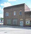 | June 25, 1992 (#92000824) | 101-107 North Bay Street 29°27′53″N 81°15′32″W / 29.464722°N 81.258889°W / 29.464722; -81.258889 (Old Bunnell State Bank Building) | Bunnell | Old Bunnell State Bank Building |
| 11 | St. Mary Catholic Church | 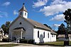 | January 25, 2024 (#100009785) | 89 St. Mary’s Place 29°24′19″N 81°11′38″W / 29.405230°N 81.193760°W / 29.405230; -81.193760 (St. Mary Catholic Church) | Bunnell | Also known as the St. Mary Mother Catholic Church. The Shrine of Saint Christopher was also included as a contributing resource. |
| 12 | Vocational Agriculture Building |  | February 21, 2007 (#07000058) | 1001 East Howe Street 29°28′19″N 81°15′17″W / 29.471944°N 81.254722°W / 29.471944; -81.254722 (Vocational Agriculture Building) | Bunnell | Part of the Florida's New Deal Resources MPS - (also known as the Little Red School House) |
| 13 | Washington Oaks Historic District | 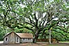 | September 30, 2009 (#09000400) | 6402 Oceanshore Boulevard 29°38′06″N 81°12′14″W / 29.635°N 81.203889°W / 29.635; -81.203889 (Washington Oaks Historic District) | Palm Coast | Washington Oaks Gardens State Park |
See also
Wikimedia Commons has media related to National Register of Historic Places in Flagler County, Florida.
- List of National Historic Landmarks in Florida
- National Register of Historic Places listings in Florida
References
- ^ The latitude and longitude information provided in this table was derived originally from the National Register Information System, which has been found to be fairly accurate for about 99% of listings. Some locations in this table may have been corrected to current GPS standards.
- ^ National Park Service, United States Department of the Interior, "National Register of Historic Places: Weekly List Actions", retrieved April 26, 2024.
- ^ Numbers represent an alphabetical ordering by significant words. Various colorings, defined here, differentiate National Historic Landmarks and historic districts from other NRHP buildings, structures, sites or objects.
- ^ "National Register Information System". National Register of Historic Places. National Park Service. March 13, 2009.
- ^ The eight-digit number below each date is the number assigned to each location in the National Register Information System database, which can be viewed by clicking the number.
- v
- t
- e
by county
- Alachua
- Baker
- Bay
- Bradford
- Brevard
- Broward
- Calhoun
- Charlotte
- Citrus
- Clay
- Collier
- Columbia
- DeSoto
- Dixie
- Duval
- Escambia
- Flagler
- Franklin
- Gadsden
- Gilchrist
- Glades
- Gulf
- Hamilton
- Hardee
- Hendry
- Hernando
- Highlands
- Hillsborough
- Holmes
- Indian River
- Jackson
- Jefferson
- Lake
- Lee
- Leon
- Levy
- Liberty
- Madison
- Manatee
- Marion
- Martin
- Miami-Dade
- Monroe
- Nassau
- Okaloosa
- Okeechobee
- Orange
- Osceola
- Palm Beach
- Pasco
- Pinellas
- Polk
- Putnam
- Santa Rosa
- Sarasota
- Seminole
- St. Johns
- St. Lucie
- Sumter
- Suwannee
- Taylor
- Union
- Volusia
- Wakulla
- Walton
- Washington


