National Register of Historic Places listings in Callaway County, Missouri

This is a list of the National Register of Historic Places listings in Callaway County, Missouri.
This is intended to be a complete list of the properties and districts on the National Register of Historic Places in Callaway County, Missouri, United States. Latitude and longitude coordinates are provided for many National Register properties and districts; these locations may be seen together in a map.[1]
There are 21 properties and districts listed on the National Register in the county, including 2 National Historic Landmarks.
This National Park Service list is complete through NPS recent listings posted April 26, 2024.[2]
Map all coordinates using OpenStreetMap
Download coordinates as:
- KML
- GPX (all coordinates)
- GPX (primary coordinates)
- GPX (secondary coordinates)
Current listings
| [3] | Name on the Register | Image | Date listed[4] | Location | City or town | Description |
|---|---|---|---|---|---|---|
| 1 | M. Fred Bell Rental Cottage |  | July 10, 1997 (#97000627) | 302 E. Fifth St. 38°50′49″N 91°56′39″W / 38.84702°N 91.94426°W / 38.84702; -91.94426 (M. Fred Bell Rental Cottage) | Fulton | |
| 2 | M. Fred Bell Speculative Cottage | 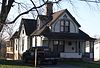 | June 30, 1995 (#95000780) | 304 E. Fifth St. 38°50′49″N 91°56′39″W / 38.847°N 91.94408°W / 38.847; -91.94408 (M. Fred Bell Speculative Cottage) | Fulton | |
| 3 | Brandon-Bell-Collier House |  | December 24, 1998 (#98001545) | 207 W. Ninth St. 38°51′17″N 91°56′42″W / 38.8547°N 91.94492°W / 38.8547; -91.94492 (Brandon-Bell-Collier House) | Fulton | |
| 4 | George Washington Carver School |  | December 2, 1996 (#96001381) | 909 Westminster 38°51′15″N 91°57′13″W / 38.85413°N 91.95355°W / 38.85413; -91.95355 (George Washington Carver School) | Fulton | |
| 5 | Cote Sans Dessein Archeological Site | Upload image | May 27, 1971 (#71000462) | Address Restricted | Tebbetts | |
| 6 | Court Street Historic Residential District | 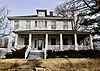 | August 15, 2007 (#07000817) | Roughly along Court St. between St. Louis and 10th Sts. 38°51′11″N 91°56′51″W / 38.853056°N 91.9475°W / 38.853056; -91.9475 (Court Street Historic Residential District) | Fulton | |
| 7 | Downtown Fulton Historic District |  | July 7, 2004 (#04000668) | Roughly bounded by 4th St., Market, 7th St. and Jefferson Ave. 38°50′55″N 91°56′56″W / 38.848611°N 91.948889°W / 38.848611; -91.948889 (Downtown Fulton Historic District) | Fulton | |
| 8 | John Augustus Hockaday House |  | September 17, 1980 (#80002321) | 105 Hockaday Ave. 38°50′31″N 91°56′55″W / 38.84199°N 91.94857°W / 38.84199; -91.94857 (John Augustus Hockaday House) | Fulton | |
| 9 | Mealy Mounds Archeological Site | Upload image | January 25, 1971 (#71000461) | Address Restricted | Mokane | |
| 10 | Middle River School | Upload image | April 1, 2024 (#100010147) | 6587 County Road 305 38°49′20″N 92°00′50″W / 38.8222°N 92.0139°W / 38.8222; -92.0139 (Middle River School) | Fulton | |
| 11 | Moore's Mill Battlefield |  | May 4, 2015 (#15000196) | Along Auxvasse Creek[5] 38°54′35″N 91°50′48″W / 38.9098°N 91.8468°W / 38.9098; -91.8468 (Moore's Mill Battlefield) | Calwood | Site of the Civil War Battle of Moore's Mill. Battle site is listed as "Address Restricted"; geolocator is for historical marker. |
| 12 | Oakley Chapel African Methodist Episcopal Church | Upload image | December 17, 2008 (#08001192) | County Road 485 at the County Road 486 junction 38°37′51″N 91°57′51″W / 38.630833°N 91.964167°W / 38.630833; -91.964167 (Oakley Chapel African Methodist Episcopal Church) | Tebbetts | |
| 13 | Pitcher Store |  | March 12, 2001 (#01000235) | 8513 Pitcher Rd. 38°45′00″N 91°57′58″W / 38.75°N 91.966111°W / 38.75; -91.966111 (Pitcher Store) | Fulton | |
| 14 | Research Cave | Upload image | October 15, 1966 (#66000415) | address restricted | Portland | |
| 15 | Richland Christian Church | Upload image | February 16, 2001 (#01000122) | 5301 Callaway Cty. Rd. 220 38°55′52″N 91°59′33″W / 38.931111°N 91.9925°W / 38.931111; -91.9925 (Richland Christian Church) | Kingdom City | |
| 16 | Robnett-Payne House |  | September 17, 1998 (#98001136) | 223 East Fifth St. 38°50′51″N 91°56′41″W / 38.84758°N 91.94485°W / 38.84758; -91.94485 (Robnett-Payne House) | Fulton | |
| 17 | Westminster College Gymnasium |  | May 23, 1968 (#68000030) | Westminster College campus 38°50′54″N 91°57′23″W / 38.84821°N 91.95628°W / 38.84821; -91.95628 (Westminster College Gymnasium) | Fulton | Winston Churchill warned here of an "iron curtain" descending |
| 18 | Westminster College Historic District |  | April 12, 1982 (#82004633) | Off Westminster Ave. 38°50′53″N 91°57′22″W / 38.848056°N 91.956111°W / 38.848056; -91.956111 (Westminster College Historic District) | Fulton | |
| 19 | White Cloud Presbyterian Church and Cemetery |  | October 12, 2010 (#10000817) | South side of Missouri Route F at intersection with County Road 232 38°52′31″N 92°04′18″W / 38.875278°N 92.071667°W / 38.875278; -92.071667 (White Cloud Presbyterian Church and Cemetery) | Fulton | |
| 20 | Dr. George M. Willing House |  | October 3, 1980 (#80002322) | 211 Jefferson St. 38°50′44″N 91°57′02″W / 38.84552°N 91.95047°W / 38.84552; -91.95047 (Dr. George M. Willing House) | Fulton | |
| 21 | Winston Churchill Memorial |  | March 16, 1972 (#72000708) | 7th St. and Westminster Ave. 38°51′00″N 91°57′16″W / 38.84998°N 91.95454°W / 38.84998; -91.95454 (Winston Churchill Memorial) | Fulton |
See also
- List of National Historic Landmarks in Missouri
- National Register of Historic Places listings in Missouri
References
Wikimedia Commons has media related to National Register of Historic Places in Callaway County, Missouri.
- ^ The latitude and longitude information provided in this table was derived originally from the National Register Information System, which has been found to be fairly accurate for about 99% of listings. Some locations in this table may have been corrected to current GPS standards.
- ^ National Park Service, United States Department of the Interior, "National Register of Historic Places: Weekly List Actions", retrieved April 26, 2024.
- ^ Numbers represent an alphabetical ordering by significant words. Various colorings, defined here, differentiate National Historic Landmarks and historic districts from other NRHP buildings, structures, sites or objects.
- ^ The eight-digit number below each date is the number assigned to each location in the National Register Information System database, which can be viewed by clicking the number.
- ^ "Callaway County Civil War Tour brochure" (PDF). Kingdom of Callaway Civil War Heritage. Retrieved 2015-05-20.
- v
- t
- e
- List of U.S. National Historic Landmarks by state:
- Alabama
- Alaska
- Arizona
- Arkansas
- California
- Colorado
- Connecticut
- Delaware
- Florida
- Georgia
- Hawaii
- Idaho
- Illinois
- Indiana
- Iowa
- Kansas
- Kentucky
- Louisiana
- Maine
- Maryland
- Massachusetts
- Michigan
- Minnesota
- Mississippi
- Missouri
- Montana
- Nebraska
- Nevada
- New Hampshire
- New Jersey
- New Mexico
- New York
- North Carolina
- North Dakota
- Ohio
- Oklahoma
- Oregon
- Pennsylvania
- Rhode Island
- South Carolina
- South Dakota
- Tennessee
- Texas
- Utah
- Vermont
- Virginia
- Washington
- West Virginia
- Wisconsin
- Wyoming
 National Register of Historic Places portal
 Category


Municipalities and communities of Callaway County, Missouri, United States | ||
|---|---|---|
County seat: Fulton | ||
| Cities |  | |
| Village | ||
| Townships | ||
| CDP | ||
| Other communities | ||
| Ghost towns | ||
| Footnotes | ‡This populated place also has portions in an adjacent county or counties | |
| ||


