National Register of Historic Places listings in Linn County, Missouri

This is a list of the National Register of Historic Places listings in Linn County, Missouri.
This is intended to be a complete list of the properties and districts on the National Register of Historic Places in Linn County, Missouri, United States. Latitude and longitude coordinates are provided for many National Register properties and districts; these locations may be seen together in a map.[1]
There are 6 properties and districts listed on the National Register in the county, including 1 National Historic Landmark.
This National Park Service list is complete through NPS recent listings posted April 26, 2024.[2]
Map all coordinates using OpenStreetMap
Download coordinates as:
- KML
- GPX (all coordinates)
- GPX (primary coordinates)
- GPX (secondary coordinates)
Current listings
| [3] | Name on the Register | Image | Date listed[4] | Location | City or town | Description |
|---|---|---|---|---|---|---|
| 1 | Linn County Courthouse | 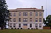 | October 14, 1999 (#99001254) | 108 High St. 39°52′46″N 93°11′21″W / 39.879444°N 93.189167°W / 39.879444; -93.189167 (Linn County Courthouse) | Linneus | |
| 2 | Linn County Jail and Sheriff's Residence | Upload image | January 16, 2001 (#00001659) | 102 N. Main St. 39°52′45″N 93°11′18″W / 39.879167°N 93.188333°W / 39.879167; -93.188333 (Linn County Jail and Sheriff's Residence) | Linneus | |
| 3 | Locust Creek Covered Bridge | 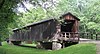 | May 19, 1970 (#70000340) | 3 miles (4.8 km) west of Laclede off U.S. Route 36 39°47′30″N 93°14′03″W / 39.791667°N 93.234167°W / 39.791667; -93.234167 (Locust Creek Covered Bridge) | Laclede | Longest of four surviving covered bridges in Missouri |
| 4 | Gen. John J. Pershing Boyhood Home |  | May 21, 1969 (#69000111) | State and Worlow Sts. 39°47′17″N 93°10′08″W / 39.788056°N 93.168889°W / 39.788056; -93.168889 (Gen. John J. Pershing Boyhood Home) | Laclede | |
| 5 | Plum Grove School | Upload image | October 22, 1994 (#94001203) | County Road 350, 3/8 miles north of its junction with County Road 346 39°48′48″N 93°12′04″W / 39.813333°N 93.201111°W / 39.813333; -93.201111 (Plum Grove School) | Laclede | |
| 6 | Uptown Theatre | Upload image | July 3, 2023 (#100009101) | 104 North Main St. U.S.A. (North Kansas Ave.) 39°42′53″N 92°57′04″W / 39.7147°N 92.9510°W / 39.7147; -92.9510 (Uptown Theatre) | Marceline |
See also
- List of National Historic Landmarks in Missouri
- National Register of Historic Places listings in Missouri
References
- ^ The latitude and longitude information provided in this table was derived originally from the National Register Information System, which has been found to be fairly accurate for about 99% of listings. Some locations in this table may have been corrected to current GPS standards.
- ^ National Park Service, United States Department of the Interior, "National Register of Historic Places: Weekly List Actions", retrieved April 26, 2024.
- ^ Numbers represent an alphabetical ordering by significant words. Various colorings, defined here, differentiate National Historic Landmarks and historic districts from other NRHP buildings, structures, sites or objects.
- ^ The eight-digit number below each date is the number assigned to each location in the National Register Information System database, which can be viewed by clicking the number.
- v
- t
- e
- List of U.S. National Historic Landmarks by state:
- Alabama
- Alaska
- Arizona
- Arkansas
- California
- Colorado
- Connecticut
- Delaware
- Florida
- Georgia
- Hawaii
- Idaho
- Illinois
- Indiana
- Iowa
- Kansas
- Kentucky
- Louisiana
- Maine
- Maryland
- Massachusetts
- Michigan
- Minnesota
- Mississippi
- Missouri
- Montana
- Nebraska
- Nevada
- New Hampshire
- New Jersey
- New Mexico
- New York
- North Carolina
- North Dakota
- Ohio
- Oklahoma
- Oregon
- Pennsylvania
- Rhode Island
- South Carolina
- South Dakota
- Tennessee
- Texas
- Utah
- Vermont
- Virginia
- Washington
- West Virginia
- Wisconsin
- Wyoming
 National Register of Historic Places portal
 Category


Municipalities and communities of Linn County, Missouri, United States | ||
|---|---|---|
County seat: Linneus | ||
| Cities |  | |
| Townships |
| |
| CDP | ||
| Other communities | ||
| Footnotes | ‡This populated place also has portions in an adjacent county or counties | |
| ||


