National Register of Historic Places listings in Warren County, Missouri
This is a list of the National Register of Historic Places listings in Warren County, Missouri.
This is intended to be a complete list of the properties and districts on the National Register of Historic Places in Warren County, Missouri, United States. Latitude and longitude coordinates are provided for many National Register properties and districts; these locations may be seen together in a map.[1]
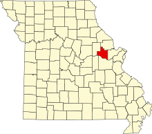
There are 8 properties and districts listed on the National Register in the county. Another 2 properties were once listed but have been removed.
This National Park Service list is complete through NPS recent listings posted March 22, 2024.[2]
Map all coordinates using OpenStreetMap
Download coordinates as:
- KML
- GPX (all coordinates)
- GPX (primary coordinates)
- GPX (secondary coordinates)
Current listings
| [3] | Name on the Register | Image | Date listed[4] | Location | City or town | Description |
|---|---|---|---|---|---|---|
| 1 | Herman H. Fortmann Building |  | May 5, 2006 (#06000332) | 207 Depot St. 38°37′48″N 91°03′44″W / 38.63°N 91.062222°W / 38.63; -91.062222 (Herman H. Fortmann Building) | Marthasville | |
| 2 | Glosemeyer General Store | Upload image | January 29, 2018 (#100002039) | 16011 Concord Hill Rd. 38°39′00″N 91°08′05″W / 38.650072°N 91.134681°W / 38.650072; -91.134681 (Glosemeyer General Store) | Marthasville | |
| 3 | Marthasville Hardware Building |  | February 14, 2008 (#08000020) | 203 Depot St. 38°37′47″N 91°03′42″W / 38.629722°N 91.061667°W / 38.629722; -91.061667 (Marthasville Hardware Building) | Marthasville | |
| 4 | Ernst Schowengerdt House | 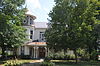 | October 3, 1980 (#80002397) | 308 E. Boone's Lick Rd. 38°48′39″N 91°08′40″W / 38.810833°N 91.144444°W / 38.810833; -91.144444 (Ernst Schowengerdt House) | Warrenton | |
| 5 | Southwestern Bell Repeater Station-Wright City |  | February 13, 2007 (#07000039) | Northeastern corner of the junction of North Service Rd. and Bell Rd. 38°49′50″N 91°02′40″W / 38.830556°N 91.044444°W / 38.830556; -91.044444 (Southwestern Bell Repeater Station-Wright City) | Wright City | |
| 6 | Starke-Meinershagen-Boeke Rural Historic District | Upload image | January 7, 1998 (#97001611) | Route 94, 5 miles west of Marthasville 38°37′36″N 91°04′47″W / 38.626667°N 91.079722°W / 38.626667; -91.079722 (Starke-Meinershagen-Boeke Rural Historic District) | Marthasville | |
| 7 | Treloar Mercantile and Farmer's Bank of Treloar HD | Upload image | March 17, 1972 (#100007419) | 2 MKT St. 38°38′38″N 91°11′19″W / 38.6438°N 91.1885°W / 38.6438; -91.1885 (Treloar Mercantile and Farmer's Bank of Treloar HD) | Treloar | |
| 8 | Warren County Courthouse and Circuit Court Building | Upload image | March 17, 1972 (#72000733) | Main St. 38°48′39″N 91°08′57″W / 38.810833°N 91.149167°W / 38.810833; -91.149167 (Warren County Courthouse and Circuit Court Building) | Warrenton | Demolished.[5] |
Former listings
| [3] | Name on the Register | Image | Date listed | Date removed | Location | City or town | Description |
|---|---|---|---|---|---|---|---|
| 1 | Borgmann Mill | Upload image | November 10, 1970 (#70000351) | December 19, 1994[6] | 5 miles east of Marthasville on County Road D 38°39′03″N 90°51′18″W / 38.650763°N 90.854923°W / 38.650763; -90.854923 (Borgmann Mill) | Marthasville | Delisted due to relocation in 1975. |
| 2 | Flanders Callaway House | Upload image | July 29, 1969 (#69000127) | December 19, 1994[7] | 1 mile south of Marthasville off Route 94 38°39′03″N 90°51′18″W / 38.650763°N 90.854923°W / 38.650763; -90.854923 (Flanders Callaway House) | Marthasville | Delisted due to relocation in 1979. |
See also
- List of National Historic Landmarks in Missouri
- National Register of Historic Places listings in Missouri
References
Wikimedia Commons has media related to National Register of Historic Places in Warren County, Missouri.
- ^ The latitude and longitude information provided in this table was derived originally from the National Register Information System, which has been found to be fairly accurate for about 99% of listings. Some locations in this table may have been corrected to current GPS standards.
- ^ National Park Service, United States Department of the Interior, "National Register of Historic Places: Weekly List Actions", retrieved March 22, 2024.
- ^ a b Numbers represent an alphabetical ordering by significant words. Various colorings, defined here, differentiate National Historic Landmarks and historic districts from other NRHP buildings, structures, sites or objects.
- ^ The eight-digit number below each date is the number assigned to each location in the National Register Information System database, which can be viewed by clicking the number.
- ^ "State Historic Preservation - DNR". Archived from the original on 2013-12-19. Retrieved 2013-04-02.
- ^ Weekly Register listing 1995
- ^ Weekly Register listing 1995
- v
- t
- e
- List of U.S. National Historic Landmarks by state:
- Alabama
- Alaska
- Arizona
- Arkansas
- California
- Colorado
- Connecticut
- Delaware
- Florida
- Georgia
- Hawaii
- Idaho
- Illinois
- Indiana
- Iowa
- Kansas
- Kentucky
- Louisiana
- Maine
- Maryland
- Massachusetts
- Michigan
- Minnesota
- Mississippi
- Missouri
- Montana
- Nebraska
- Nevada
- New Hampshire
- New Jersey
- New Mexico
- New York
- North Carolina
- North Dakota
- Ohio
- Oklahoma
- Oregon
- Pennsylvania
- Rhode Island
- South Carolina
- South Dakota
- Tennessee
- Texas
- Utah
- Vermont
- Virginia
- Washington
- West Virginia
- Wisconsin
- Wyoming
 National Register of Historic Places portal
 Category


Municipalities and communities of Warren County, Missouri, United States | ||
|---|---|---|
County seat: Warrenton | ||
| Cities |  | |
| Villages | ||
| Townships |
| |
| Unincorporated communities | ||
| Ghost towns |
| |
| Footnotes | ‡This populated place also has portions in an adjacent county or counties | |
| ||


