National Register of Historic Places listings in Gasconade County, Missouri

This is a list of the National Register of Historic Places listings in Gasconade County, Missouri.
This is intended to be a complete list of the properties and districts on the National Register of Historic Places in Gasconade County, Missouri, United States. Latitude and longitude coordinates are provided for many National Register properties and districts; these locations may be seen together in a map.[1]
There are 9 properties and districts listed on the National Register in the county.
This National Park Service list is complete through NPS recent listings posted April 26, 2024.[2]
Map all coordinates using OpenStreetMap
Download coordinates as:
- KML
- GPX (all coordinates)
- GPX (primary coordinates)
- GPX (secondary coordinates)
Current listings
| [3] | Name on the Register | Image | Date listed[4] | Location | City or town | Description |
|---|---|---|---|---|---|---|
| 1 | Hermann Historic District | 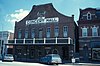 | February 1, 1972 (#72000712) | Roughly bounded by E. Wharf, Mozart, E. 5th, and Gellert Sts.; also 214 and 304 Franklin, 301-501 Gellert, and 2202 Route 100; also roughly bounded by Wharf, 1st, Mozart, 5th, Schiller, 4th, Gutenberg, and Reserve Sts. 38°42′19″N 91°26′04″W / 38.705278°N 91.434444°W / 38.705278; -91.434444 (Hermann Historic District) | Hermann | Second and third sets of boundaries represent boundary increases of November 29, 2006 and October 30, 2009 respectively |
| 2 | Kotthoff-Weeks Farm Complex | Upload image | March 28, 1983 (#83000988) | Off Route J 38°38′04″N 91°31′50″W / 38.634444°N 91.530556°W / 38.634444; -91.530556 (Kotthoff-Weeks Farm Complex) | Hermann | |
| 3 | Old Stone Hill Historic District |  | May 21, 1969 (#69000102) | Bounded roughly by W. 12th, Goethe and Jefferson Sts., and Iron Rd. 38°41′48″N 91°26′45″W / 38.696667°N 91.445833°W / 38.696667; -91.445833 (Old Stone Hill Historic District) | Hermann | See Stone Hill Winery |
| 4 | Peenie Petroglyph Archeological Site | Upload image | July 29, 1969 (#69000101) | Address Restricted | Bem | |
| 5 | William Poeschel House | Upload image | June 21, 1990 (#90000982) | W. 10th St. approximately 2 miles (3.2 km) west of the Hermann city limits 38°41′43″N 91°28′11″W / 38.695278°N 91.469722°W / 38.695278; -91.469722 (William Poeschel House) | Hermann | |
| 6 | The Rotunda | Upload image | November 2, 1995 (#95001180) | City Park, Washington St. 38°41′57″N 91°26′32″W / 38.699167°N 91.442222°W / 38.699167; -91.442222 (The Rotunda) | Hermann | |
| 7 | Ruskaup House | Upload image | March 29, 1983 (#83000989) | West of Drake on U.S. Route 50 38°29′05″N 91°31′53″W / 38.484722°N 91.531389°W / 38.484722; -91.531389 (Ruskaup House) | Drake | |
| 8 | Shobe-Morrison House | Upload image | February 10, 1983 (#83000990) | West of Morrison off Route 100 38°40′24″N 91°38′16″W / 38.673333°N 91.637778°W / 38.673333; -91.637778 (Shobe-Morrison House) | Morrison | |
| 9 | Vallet-Danuser House | Upload image | September 23, 1982 (#82003136) | East of Hermann on Route 100 38°42′16″N 91°24′54″W / 38.704444°N 91.415°W / 38.704444; -91.415 (Vallet-Danuser House) | Hermann |
See also
- List of National Historic Landmarks in Missouri
- National Register of Historic Places listings in Missouri
References
Wikimedia Commons has media related to National Register of Historic Places in Gasconade County, Missouri.
- ^ The latitude and longitude information provided in this table was derived originally from the National Register Information System, which has been found to be fairly accurate for about 99% of listings. Some locations in this table may have been corrected to current GPS standards.
- ^ National Park Service, United States Department of the Interior, "National Register of Historic Places: Weekly List Actions", retrieved April 26, 2024.
- ^ Numbers represent an alphabetical ordering by significant words. Various colorings, defined here, differentiate National Historic Landmarks and historic districts from other NRHP buildings, structures, sites or objects.
- ^ The eight-digit number below each date is the number assigned to each location in the National Register Information System database, which can be viewed by clicking the number.
- v
- t
- e
- List of U.S. National Historic Landmarks by state:
- Alabama
- Alaska
- Arizona
- Arkansas
- California
- Colorado
- Connecticut
- Delaware
- Florida
- Georgia
- Hawaii
- Idaho
- Illinois
- Indiana
- Iowa
- Kansas
- Kentucky
- Louisiana
- Maine
- Maryland
- Massachusetts
- Michigan
- Minnesota
- Mississippi
- Missouri
- Montana
- Nebraska
- Nevada
- New Hampshire
- New Jersey
- New Mexico
- New York
- North Carolina
- North Dakota
- Ohio
- Oklahoma
- Oregon
- Pennsylvania
- Rhode Island
- South Carolina
- South Dakota
- Tennessee
- Texas
- Utah
- Vermont
- Virginia
- Washington
- West Virginia
- Wisconsin
- Wyoming
 National Register of Historic Places portal
 Category


Municipalities and communities of Gasconade County, Missouri, United States | ||
|---|---|---|
County seat: Hermann | ||
| Cities |  | |
| Townships | ||
| Unincorporated community | ||
| Ghost towns | ||
| Footnotes | ‡This populated place also has portions in an adjacent county or counties | |
| ||


