National Register of Historic Places listings in Lincoln County, Missouri

This is a list of the National Register of Historic Places listings in Lincoln County, Missouri.
This is intended to be a complete list of the properties and districts on the National Register of Historic Places in Lincoln County, Missouri, United States. Latitude and longitude coordinates are provided for many National Register properties and districts; these locations may be seen together in a map.[1]
There are 5 properties and districts listed on the National Register in the county.
This National Park Service list is complete through NPS recent listings posted March 22, 2024.[2]
Map all coordinates using OpenStreetMap
Download coordinates as:
- KML
- GPX (all coordinates)
- GPX (primary coordinates)
- GPX (secondary coordinates)
Current listings
| [3] | Name on the Register | Image | Date listed[4] | Location | City or town | Description |
|---|---|---|---|---|---|---|
| 1 | Camp Sherwood Forest Historic District | Upload image | March 4, 1985 (#85000512) | Southwest of Troy in Cuivre State Park 39°02′35″N 90°54′57″W / 39.043056°N 90.915833°W / 39.043056; -90.915833 (Camp Sherwood Forest Historic District) | Troy | |
| 2 | Cuivre River State Park Administrative Area Historic District | Upload image | March 4, 1985 (#85000514) | Southwest of Troy in Cuivre State Park 39°00′22″N 90°55′36″W / 39.006111°N 90.926667°W / 39.006111; -90.926667 (Cuivre River State Park Administrative Area Historic District) | Troy | Administrative area within Cuivre River State Park |
| 3 | Downtown Troy Historic District | 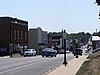 | October 30, 2013 (#13000857) | Bounded by Annie Ave., 2nd, Marble & Court Sts. 38°58′45″N 90°58′52″W / 38.979245°N 90.981113°W / 38.979245; -90.981113 (Downtown Troy Historic District) | Troy | |
| 4 | Lock and Dam No. 25 Historic District |  | March 10, 2004 (#04000184) | 10 Sandy Slough Rd. 39°00′16″N 90°41′26″W / 39.004400°N 90.690600°W / 39.004400; -90.690600 (Lock and Dam No. 25 Historic District) | Winfield | |
| 5 | Old Rock House |  | October 18, 1972 (#72000721) | 2nd and Mill Sts. 38°56′57″N 90°54′53″W / 38.949167°N 90.914722°W / 38.949167; -90.914722 (Old Rock House) | Moscow Mills |
See also
- List of National Historic Landmarks in Missouri
- National Register of Historic Places listings in Missouri
References
Wikimedia Commons has media related to National Register of Historic Places in Lincoln County, Missouri.
- ^ The latitude and longitude information provided in this table was derived originally from the National Register Information System, which has been found to be fairly accurate for about 99% of listings. Some locations in this table may have been corrected to current GPS standards.
- ^ National Park Service, United States Department of the Interior, "National Register of Historic Places: Weekly List Actions", retrieved March 22, 2024.
- ^ Numbers represent an alphabetical ordering by significant words. Various colorings, defined here, differentiate National Historic Landmarks and historic districts from other NRHP buildings, structures, sites or objects.
- ^ The eight-digit number below each date is the number assigned to each location in the National Register Information System database, which can be viewed by clicking the number.
- v
- t
- e
- List of U.S. National Historic Landmarks by state:
- Alabama
- Alaska
- Arizona
- Arkansas
- California
- Colorado
- Connecticut
- Delaware
- Florida
- Georgia
- Hawaii
- Idaho
- Illinois
- Indiana
- Iowa
- Kansas
- Kentucky
- Louisiana
- Maine
- Maryland
- Massachusetts
- Michigan
- Minnesota
- Mississippi
- Missouri
- Montana
- Nebraska
- Nevada
- New Hampshire
- New Jersey
- New Mexico
- New York
- North Carolina
- North Dakota
- Ohio
- Oklahoma
- Oregon
- Pennsylvania
- Rhode Island
- South Carolina
- South Dakota
- Tennessee
- Texas
- Utah
- Vermont
- Virginia
- Washington
- West Virginia
- Wisconsin
- Wyoming
 National Register of Historic Places portal
 Category


Municipalities and communities of Lincoln County, Missouri, United States | ||
|---|---|---|
County seat: Troy | ||
| Cities |  | |
| Villages | ||
| Townships | ||
| Unincorporated communities | ||
| Ghost towns | ||
| ||


