National Register of Historic Places listings in Phelps County, Missouri

This is a list of the National Register of Historic Places listings in Phelps County, Missouri.
This is intended to be a complete list of the properties and districts on the National Register of Historic Places in Phelps County, Missouri, United States. Latitude and longitude coordinates are provided for many National Register properties and districts; these locations may be seen together in a map.[1]
There are 11 properties and districts listed on the National Register in the county.
This National Park Service list is complete through NPS recent listings posted April 26, 2024.[2]
Map all coordinates using OpenStreetMap
Download coordinates as:
- KML
- GPX (all coordinates)
- GPX (primary coordinates)
- GPX (secondary coordinates)
Current listings
| [3] | Name on the Register | Image | Date listed[4] | Location | City or town | Description |
|---|---|---|---|---|---|---|
| 1 | Community Theater | Upload image | December 20, 2006 (#06001134) | 117 First St. 37°54′52″N 91°54′05″W / 37.914444°N 91.901389°W / 37.914444; -91.901389 (Community Theater) | Newburg | |
| 2 | Gourd Creek Cave Archeological Site | Upload image | July 29, 1969 (#69000121) | Address Restricted | Newburg | |
| 3 | Headquarters, Rolla Division of the Bureau of Mines |  | April 24, 2017 (#100000910) | 1300 N. Bishop Ave. 37°57′15″N 91°46′36″W / 37.954196°N 91.776715°W / 37.954196; -91.776715 (Headquarters, Rolla Division of the Bureau of Mines) | Rolla | Demolished in 2021 |
| 4 | Maramec Iron Works District | 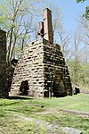 | April 16, 1969 (#69000122) | 7 miles S of St. James on MO 8 37°57′21″N 91°32′19″W / 37.955833°N 91.538611°W / 37.955833; -91.538611 (Maramec Iron Works District) | St. James | |
| 5 | National Bank of Rolla Building |  | December 28, 2001 (#01001380) | 718 Pine St. 37°56′59″N 91°46′16″W / 37.949722°N 91.771111°W / 37.949722; -91.771111 (National Bank of Rolla Building) | Rolla | |
| 6 | Ozark Iron Furnace Stack | Upload image | June 15, 1970 (#70000345) | 2 miles W of Newburg 37°54′56″N 91°55′52″W / 37.915556°N 91.931111°W / 37.915556; -91.931111 (Ozark Iron Furnace Stack) | Newburg | |
| 7 | Phelps County Courthouse |  | January 7, 1993 (#92001745) | Junction of Third and Main Sts. 37°56′45″N 91°46′22″W / 37.945833°N 91.772778°W / 37.945833; -91.772778 (Phelps County Courthouse) | Rolla | |
| 8 | Phelps County Jail |  | May 10, 1990 (#90000766) | Park St. between Second and Third Sts. 37°56′45″N 91°46′27″W / 37.945833°N 91.774167°W / 37.945833; -91.774167 (Phelps County Jail) | Rolla | |
| 9 | Rolla Ranger Station Historic District |  | August 4, 2003 (#03000717) | Bridge School Road and Kingshighway 37°56′37″N 91°47′23″W / 37.943611°N 91.789722°W / 37.943611; -91.789722 (Rolla Ranger Station Historic District) | Rolla | |
| 10 | St. James Chapel |  | July 28, 1983 (#83001035) | Church and Meramec Sts. 37°59′38″N 91°36′49″W / 37.993889°N 91.613611°W / 37.993889; -91.613611 (St. James Chapel) | St. James | |
| 11 | Verkamp Shelter | Upload image | July 30, 1974 (#74001089) | Address Restricted | St. James |
See also
- List of National Historic Landmarks in Missouri
- National Register of Historic Places listings in Missouri
References
Wikimedia Commons has media related to National Register of Historic Places in Phelps County, Missouri.
- ^ The latitude and longitude information provided in this table was derived originally from the National Register Information System, which has been found to be fairly accurate for about 99% of listings. Some locations in this table may have been corrected to current GPS standards.
- ^ National Park Service, United States Department of the Interior, "National Register of Historic Places: Weekly List Actions", retrieved April 26, 2024.
- ^ Numbers represent an alphabetical ordering by significant words. Various colorings, defined here, differentiate National Historic Landmarks and historic districts from other NRHP buildings, structures, sites or objects.
- ^ The eight-digit number below each date is the number assigned to each location in the National Register Information System database, which can be viewed by clicking the number.
- v
- t
- e
- List of U.S. National Historic Landmarks by state:
- Alabama
- Alaska
- Arizona
- Arkansas
- California
- Colorado
- Connecticut
- Delaware
- Florida
- Georgia
- Hawaii
- Idaho
- Illinois
- Indiana
- Iowa
- Kansas
- Kentucky
- Louisiana
- Maine
- Maryland
- Massachusetts
- Michigan
- Minnesota
- Mississippi
- Missouri
- Montana
- Nebraska
- Nevada
- New Hampshire
- New Jersey
- New Mexico
- New York
- North Carolina
- North Dakota
- Ohio
- Oklahoma
- Oregon
- Pennsylvania
- Rhode Island
- South Carolina
- South Dakota
- Tennessee
- Texas
- Utah
- Vermont
- Virginia
- Washington
- West Virginia
- Wisconsin
- Wyoming
 National Register of Historic Places portal
 Category


Municipalities and communities of Phelps County, Missouri, United States | ||
|---|---|---|
County seat: Rolla | ||
| Cities |  | |
| Townships | ||
| Unincorporated communities | ||
| Ghost towns | ||
| ||


